Geocages
Geocages
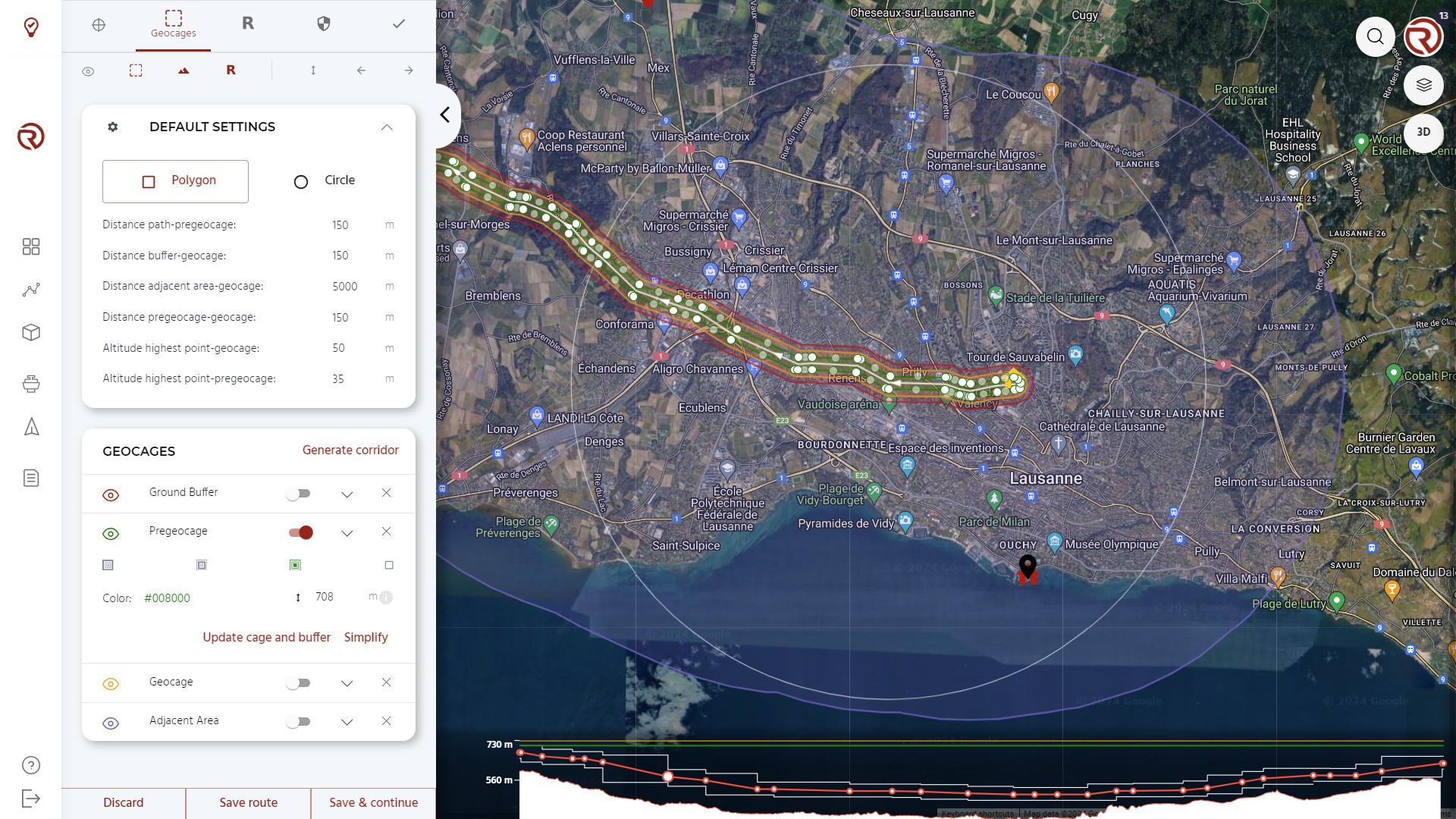
The "Geocages" menu allows to work with different types of areas and volumes whose goal is to increase the safety of the operations by ensuring the containment of the UA within the operational volume and ground buffer.
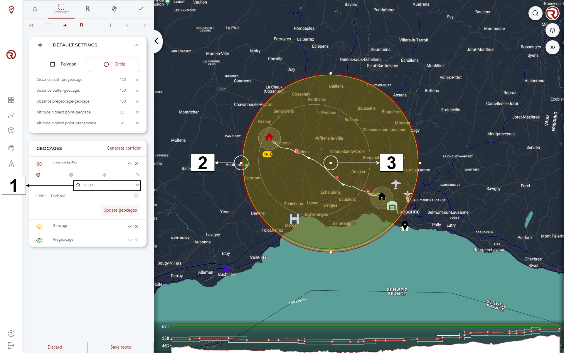
The surfaces prepared can be differentiated by their shape (polygons or circles) and their nature. There are five types of surfaces:
- Pregeocage: pregeocages and geocages are similar en terms of their capabilities. However, the idea behind pregeocage is to execute a less drastic measure when the UAS crosses it, including warning to the remote crew. Typically, it is expected to consider the pregeocage as the bounday between the contingency volume and the flight geography.
- Default colour: green.
- Geocage: geocages are typically the external border of the contingency and operational volume. If the UAS crosses it, it is programmed to automatically trigger a predefined failsafe action (see Safety settings).
- Default colour: orange.
- Ground buffer: it represents the area in which the UAS could fall in case of terminating it after crossing the geocage.
- Default colour: red.
- This area does not affect the operation and crossing it will not trigger any warning or measure. However, it is used to support operational risk assessments and discussions with civil aviation authorities.
- Adjacent area: the adjacent area (based on JARUS SORA Main Body 2.5) represents the ground area adjacent to the ground risk buffer where it is reasonably expected that the UA may crash after a loss of control situation resulting in a flyaway. For simplicity, in RigiCloud the adjacent area starts at the outer borders of the operational volume (geocage).
- Default colour: purple.
- This area does not affect the operation and crossing it will not trigger any warning or measure. However, it is used to support operational risk assessments and discussions with civil aviation authorities.
- Polygon: generic polygons are volumes with only visual purposes and do not affect the operation.
- Default colour: yellow.
- This area does not affect the operation and crossing it will not trigger any warning or measure.
The size and altitude of the different areas and volumes should be based on the models defined in the UAS Flight Manual, operational requirements and/or regulations. Civil aviation authorities may require to justify the sizes and altitudes selected.
Geocage Default Settings
Under "DEFAULT SETTINGS", the shape of the surface (polygon or circle) can be defined, as well default distances between surfaces and their vertical limits.
From top to bottom:
- Show/hide geocage default settings: allows to show/hide geocage default values.
- Shape selector:
- Polygon allows to draw polygonal surfaces.
- Circle allows to draw circular surfaces.
- Distance path-pregeocage: predefined distance between the flight path (waypoints) and the pregeocage (only when the geocages are generate through "Generate corridor"). Equivalent to half the width of the flight geography according to the SORA semantic model.
- Distance pregeocage-geocage: predefined distance betwen the geocage and the pregeocage. It should be large enough to allow the remote crew to react in case of surpassing it (if "warning" is the predefined failsafe action). Equivalent to the width of the contingency volume according to the SORA semantic model.
- Distance geocage-buffer: predefined distance between the geocage and the ground buffer. Typically, following the 1:1 rule, it should be at least as large as the vertical limit of the geocage. Equivalent to the width of the ground risk buffer according to the SORA semantic model.
- Distance geocage-adjacent area: predefined distance between the geocage and the adjacent area. Roughly equivalent to the width of the adjacent ground area according to the SORA semantic model (SORA 2.5).
- Altitude highest point-pregeocage: vertical buffer between the highest waypoint and the pre-geocage.
- Altitude highest point-geocage: vertical buffer between the highest waypoint and the geocage.
Altitudes and distances shall be checked to confirm that they correspond to the desired/required limits. Altitudes can be compared in the altitude graph and the 3D view. As for the horizontal distances, the ruler or the grid can be used. If the parameters differ to the paremeter selected, the geocage/pregeocage/ground buffer shall be updated.
Geocage creation
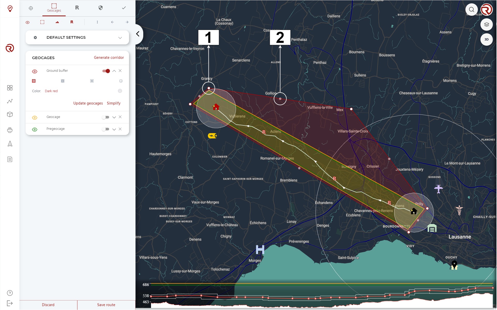
Geocages and other containment areas/volumes can be created in three ways:
- Automatic generation through Generate corridor.
- Manual generation: clicking on the map to generate/move vertices for the selected type of area/volume. See Geocage edition.
- Automatic update through "Update cage" (the term cage will be different for the different types of areas/volumes). See Update cages.
Under "GEOCAGES", users may select the type of the area/volume, edit their altitudes and update/simplify/remove surfaces. When there is at least one area/volume available, the following features and information will be displayed.
- Show/hide area/volume
- Area/volume type: shows the type of the area/volume.
- Enable/disable edit mode: allows to enable manual edition of the area/volume. See Geocage edition.
- Remove area/volume
- Surface type selector: allows to choose the type of the area/volume. From left to right:
- Ground buffer
- Geocage
- Pregeocage
- Polygon
- Adjacent areas can only be created when generating an automatic corridor or when updating other geocages.
- Colour selector: allows to change the colour of the given area/volume.
- Altitude definition: allows to change the vertical limit of the given surface (in AMSL).
- Altitudes can be updated automatically from the highest waypoints (defined in the geocage default settings) or defined manually (for example, when a particular AMSL limit is requested from competent authorities).
- Altitudes can only be defined for volumes (geocages, pregeocages and polygons).
- Radius definition: for circular surfaces, the radius can be edited parametrically from the list of geocages.
- Show information: allows to show/hide additional information of the surface.
- Additional information: shows additional information of the area/volume. From left to right:
- Surface of the area/projected volume (in km2).
- Number of vertices (only in polygons). In geocages, for redundancy, this number should be below 256 in order to have the geocage stored both in the autopilot and the onboard computer.
- Vertical limit (AMSL). Only for volumes (geocages, pregeocages and polygons).
- Update [cages]: see Update cages.
- Simplify: simplifies the shape of the surface. This tool should only be used if there are more than 255 vertices in the geocage. If this tool is used, the user shall remember to check that the flight plan is still within the different surfaces and that the level of safety is still compatible with the authorisations.
See Operation structure for more information on how to properly set geocages, pregeocages and ground buffers
Generate corridor
This tool allows to automatically generate a corridor based on the geocage default settings, including "Distance path-pregeocage". Manual modifications migth still be needed, whether it is to reduce their size locally (e.g. during multicopter phases) or to increase it (e.g. in a location where more space is needed to executing certain contingency manoeuvre).
Geocage edition
Polygons
Vertices can be added by simply clicking on empty locations in the map. Existing vertices can be edited by clicking on them and dragging them to the new location. Intermediary vertices (white circles) can be added by clicking on and dragging intermediary points between vertices (semi-transparent circles). The user shall ensure that there is always at least one path connecting two different points without crossing the geocage.
- Example of vertice
- Example of intermediary vertice
Circles
The center of a circle can be added by clicking on the map. To edit its position, it can be dragged within the map. The radius can be modified directly in the geocage menu or by dragging the external points of the circle on the map.
- Radius: here the radius of the geocage can be modified.
- Example of external point
- Example of circle center
Update cages
Depending on the type of area selected, by clicking on "Update cage", the other types of areas/volumes will automatically be updated/generated based on the values defined in "Geocage settings". The altitudes are also modified based on such settings, but only the updated area/volumes. The altitude of the reference area/volume is kept as it is. If a different value is desired, the user needs to modify it manually or update [cages] from a different reference area/volume.